Primary Production from MODIS
Topics
- Access
- Description
- Parameters
- Coverage, spatial and temporal resolution
- Data quality
- Contact person
- References
- Data citation
Access
UNRESTRICTED:
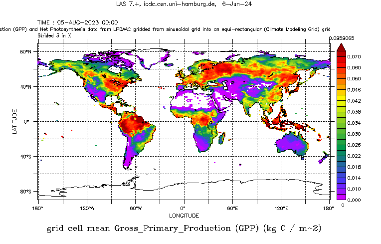
- View global GPP data (8-daily) at LAS
- Get global GPP data via HTTP (wget shell script to get all data)
- Get global 8-daily GPP data from the ZFDM of the UHH: https://doi.org/10.25592/uhhfdm.14449
- Get tiled 8-daily GPP data from the ZFDM of the UHH: https://doi.org/10.25592/uhhfdm.14463
- Access global 8-daily GPP data via OPeNDAP
- Get global yearly NPP & GPP data from the ZFDM of the UHH: https://doi.org/10.25592/uhhfdm.14635
- Get tiled yearly NPP & GPP data from the ZFDM of the UHH: https://doi.org/10.25592/uhhfdm.14633
RESTRICTED: This link to the data set is only available for a restricted user group. The data set is only accessible in CEN/MPI net or accessible from external nets with a customer account. Please contact ICDC if you would like to access this data from outside the network.
- Get 8-daily GPP data via our MODIS Tiles Download Tool (choose a tile and get the corresponding data path)
- Data access via file system: /data/icdc/land/modis_gpp/
Description
This data set comprises the 8- daily (MOD17A2HGF) and the annual (MOD17A3HGF) gross primary production (GPP) together with net photosynthesis (8-daily) or the net primary productivity (annual) and various quality and confidence flags derived from MODIS collection 6.1 radiance and reflectance observations.
Derivation of the primary production is based on
- plant NPP is directly related to the absorbed solar energy;
- NDVI and EVI as observed, e.g. by MODIS, are connected with the solar energy absorbed by the plants, and
- biophysical reasons determine the ratio between actual and potential efficiency of conversion of solar energy by the plants.
Based on this concept, and expressed very simple, the fraction of absorbed photosynthetically active radiation (FAPAR) can be linked via the efficiency of the plants to convert solar radiation into their growth, to estimate primary production. This conversion efficiency depends on biome type, LAI, and evapotranspiration & respiration conditions. Hence derivation of the two primary production parameters GPP and NPP offered here requires data about land cover, LAI, FAPAR, soil and atmospheric conditions as input as described in the User Guide (see references).
The data sets (MODIS collection 6.1) offered here (MOD17A2HGF) have 8-daily or (MOD17A3HGF) annual temporal resolution. We offer the gap-filled data set on the MODIS tiles and In addition as global maps with 0.5 degree grid resolution.
Last update of data set at ICDC: May 8, 2025.
Parameters
| Name | Unit / Range |
|---|---|
| Gross Primary Production (GPP) | kg C m-2 |
| Net Primary Production (NPP) | kg C m-2 (annual) |
| Net Photosynthesis | kg C m-2 (8-daily) |
| Quality flag | -- (11 ... 14; 21 ... 24; 111 ... 114; 121 ... 124; see information in NetCDF file) |
| Confidence flag | -- (0 ... 4; see information in NetCDF file) |
| Name | Unit / Range |
|---|---|
| Mean Gross Primary Production (GPP) | kg C m-2 |
| Mean Net Primary Production (NPP) | kg C m-2 (annual) |
| Mean Net Photosynthesis | kg C m-2 (8-daily) |
| Gross Primary Production (GPP) standard deviation | kg C m-2 |
| Net Primary Production (NPP) standard deviation | kg C m-2 (annual) |
| Net Photosynthesis standard deviation | kg C m-2 (8-daily) |
| Number of valid values | -- (0 ... 14400) |
| Number of used confidence and quality control flags | -- (0 ... 14400) |
| Mean confidence flag | -- (0 ... 4; see information in NetCDF file) |
| Fraction of confidence flag "best" | % |
| Fraction of confidence flag "good" | % |
| Fraction of confidence flag "useful" | % |
| Fraction of confidence flag "other" | % |
| Fraction of confidence flag "not usable" | % |
| Primary cloudflag | . |
| Primary cloudflag fraction | % |
Coverage, spatial and temporal resolution
Period and temporal resolution:
- Gross Primary Production (GPP): 2000-02-18 to 2024-12-31 (TERRA)
- 8-daily (see section Data Quality for a list of 8-day periods with corrupt data)
- Annual (GPP and NPP): 2001-01-01 to 2024-12-31 (TERRA)
Coverage and spatial resolution:
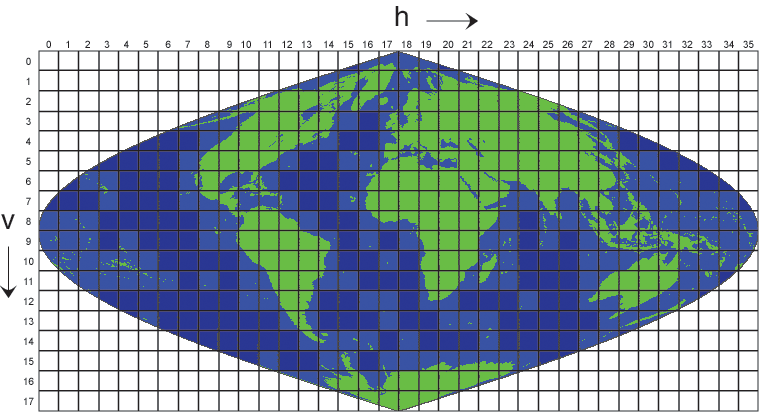
- split into tiles of ~10° geogr. latitude x ~10+° geogr. longitude // global
- Spatial resolution: 500m x 500m (MODIS sinusoidal Grid, see fig. 2) // 0.5 degrees x 0.5 degrees (global)
- Geographical longitude: depends on tile // 179.75°W to 179.75°E (global)
- Geographical latitude: depends on tile // 89.75°S to 89.75°N (global)
- Dimension: 2400 rows x 2400 columns for each tile // 720 rows x 1440 columns (global)
- Altitude: follows topography
- Remark: Geographical latitude and longitude per grid cell in separate file for each tile
Format:
- NetCDF
Data quality
This data set is based on re-calibrated MODIS observations of collection 6.1.
The data set offered here contains 2 different flags: one quality flag and one confidence flag.
The quality flag comes in two groups of values < 100 and values > 100, the latter indicating "good quality" according to the MODLAND criteria. Subdivisions give information about MODIS sensor detector reliability and cloud cover.
| Flag | Description |
|---|---|
| 0 | very best possible |
| 1 | good, very usable, but not the best (FPAR/LAI saturation occurred) |
| 2 | substandard due to geometry problems, use with caution |
| 3 | substandard due to other than geometry problems, use with caution |
| 4 | Could not retrieve pixel, not produced, non-terrestrial biome |
The global product contains in addition to the mean quantities their standard deviations, the number of valid data per grid cells and the mean confidence flag. Also, the fractions of the confidence flags per grid cell, the primary cloud flag and its fraction per grid cell is included.
Several 8-day periods contain corrupt data - either only on separate tiles or also widespread. This has an effect on the global data of course unfortunately.
Periods with corrupt data:
- 2022: 8-daily Data of this year have been reprocessed and uploaded onto the server after completion of data of the year 2023. I did not find the data overly useful because for one tile there were often tile data from three different reprocessing times available which made it impossible to select those tiles that would be needed for a consistent mapping of the data onto a global grid. In addition to that the values obtained in the global maps were not credible and seemed to indicate a wrong seasonal cycle. Therefore we do not offer data from 2022 at all.
Contact
LP DAAC User Services
U.S. Geological Survey (USGS)
Center for Earth Resources Observation and Science (EROS)
email: LPDAAC (at) eos.nasa.govProf. Steven Running
Dept. of Ecosystem and Conservation Sciences
University of Montana, Missoula, Montana, U.S.
email: swr (at) ntsg.umt.eduAlvaro Moreno
Dept. of Ecosystem and Conservation Sciences
University of Montana, Missoula, Montana, U.S.
email: alvaro.moreno (at) ntsg.umt.eduStefan Kern
University of Hamburg
email: stefan.kern (at) uni-hamburg.de
References
Literature:
- MODIS Primary Production User Guide (pdf, not barrier free)
- MOD17 ATBD (pdf, not barrier free)
- Running, S. W., et al., A continuous satellite-derived measure of global terrestrial primary production. Bioscience, 54(6), 547-560, 2004 (pdf, not barrier free)
- Running, S. W., A measurable planetary boundary layer for the biosphere. Science, 337(6101), 1458-1459, 2012 (pdf, not barrier free)
- Zhao, M., F. A. Heinsch, R. R. Nemani, and S. W. Running, Improvements of the MODIS terrestrial gross and net primary production global data set. Rem. Sens. Environ., 95(2), 164-176, 2005 (pdf, not barrier free)
- Zhu, X., et al., 2018, Underestimates of Grassland Gross Primary Production in MODIS standard products. Remote Sensing, 10(11), 1771, doi: 10.3390/rs10111771.
- Lyapustin et al., Scientific impact of MODIS C5 calibration degradation and C6+ improvements, Atmos. Meas. Tech., 7, 4353–4365, 2014 (pdf, not barrier free)
Websites:
- Numerical Terradynamic Simulation Group, http://www.ntsg.umt.edu/
Data citation
Please cite the data as follows:
Tiles:
8-daily: Running, S., and Zhao, M.. (2024). MODIS/Terra Gross Primary Production Gap-Filled 8-Day L4 Global 500m SIN Grid V061. NASA EOSDIS Land Processes DAAC. https://doi.org/10.5067/MODIS/MOD17A2HGF.061 [last access: March 27, 2025], provided in netCDF file format by the Integrated Climate Data Center ICDC, CEN, University of Hamburg (https://doi.org/10.25592/uhhfdm.14463 [last access: your access date])
Annual: Running, S., and Zhao, M.. (2024). MODIS/Terra Net & Gross Primary Production Gap-Filled Yearly L4 Global 500m SIN Grid V061. NASA EOSDIS Land Processes DAAC. https://doi.org/10.5067/MODIS/MOD17A3HGF.061 [last access: March 27, 2025], provided in netCDF file format by the Integrated Climate Data Center ICDC, CEN, University of Hamburg (https://doi.org/10.25592/uhhfdm.14633 [last access: your access date])
Global:
8-daily: Globally gridded MODIS GPP and net photosynthesis data at 0.5 resolution derived at ICDC (https://www.cen.uni-hamburg.de/icdc/, https://doi.org/10.25592/uhhfdm.14449 [last access: your access data]) from Running, S., and Zhao, M. (2024). MODIS/Terra Gross Primary Productivity Gap-Filled 8-Day L4 Global 500m SIN Grid V061. NASA EOSDIS Land Processes DAAC. https://doi.org/10.5067/MODIS/MOD17A2HGF.061 [last access: March 27, 2025].
Annual: Globally gridded MODIS GPP and net photosynthesis data at 0.5 resolution derived at ICDC (https://www.cen.uni-hamburg.de/icdc/, https://doi.org/10.25592/uhhfdm.14635 [last access: your access data]) from Running, S., and Zhao, M. (2024). MODIS/Terra Gross Primary Productivity Gap-Filled Yearly L4 Global 500m SIN Grid V061. NASA EOSDIS Land Processes DAAC. https://doi.org/10.5067/MODIS/MOD17A3HGF.061 [last access: March 27, 2025].
and with the following acknowledgments:
Thanks to ICDC, CEN, University of Hamburg for data support.