Surface Albedo (CLARA-A3) from EUMETSAT CM-SAF
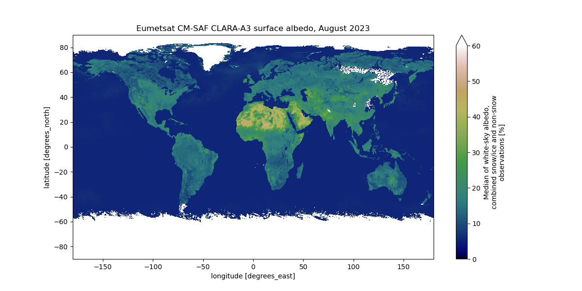 Surface albedo for August 2023, Eumetsat CM-SAF Surface Albedo (CLARA-A3), Copyright: UHH/StefanKern
Topics
- Access
- Description
- Parameters
- Coverage, spatial and temporal resolution
- Data quality
- Contact person
- References
- Data citation
Access
RESTRICTED: This link to the data set is only available for a restricted user group. The data set is only accessible in CEN/MPI net or accessible from external nets with a customer account. Please contact ICDC if you would like to access this data from outside the network.
- Data access via file system: /data/icdc/land/eumetsat_clara3_surfacealbedo/
Description
CLARA-A3 stands for "CM SAF cLouds, Albedo RAdiation data record, AVHRR-based, Edition 3" and comprises a suite of radiation and cloud parameters derived within the EUMETSAT Climate Monitoring Satellite Application Facility (CM-SAF) from Advanced Very High Resolution Radiometer (AVHRR) data.
For information about the data products we refer to the respective CM-SAF web page.
Here we offer (for internal use only) the surface albedo product. Products are also available at ICDC for radiation and clouds.
Last update of data set at ICDC: February 22 2024.
Parameters
All four statistical moments (mean, standard deviation, kurtosis, skewness) and the median value for blue-sky, white-sky, and black-sky albedo for no snow/ice surfaces / only snow/ice covered surfaces / combined no snow/ice & snow/ice surfaces |
|---|
All four statistical moments + median of various cloud probability measures for various cases |
All four statistical moments + median of fraction of direct irradiance for various cases |
All four statistical moments + median of sun zenith and azimuth angle |
Coverage, spatial and temporal resolution
Period and temporal resolution:
- 1979-01 to 2023-11 // 1979-01 -01 to 2023-12-16
- Monthly / Pentad (the latter we only offer pol centred)
Coverage and spatial resolution:
- Global // pol centered
- Spatial resolution: 0.25 degrees x 0.25 degrees, equally spaced lat/lon grid (Climate Modeling Grid, CMG) // 25 km x 25 km EASE grid
- Geographic longitude:-179.875°E to 179.875°E
- Geographic latitude: -89.875°N to 89.875°N // 30.36°N to 90.0°N or -90.0°N to -30.36°N
- Dimension: 1440 columns x 720 rows // 360 columns x 360 rows
- Altitude: following terrain
Format:
- NetCDF
Data quality
See the respective CM-SAF web page and the references.
Contact
Climate Monitoring Satellite Application Facility (CM-SAF)
www.cmsaf.eu
email: contact.cmsaf (at) dwd.deStefan Kern
University of Hamburg
E-Mail: stefan.kern (at) uni-hamburg.de
References
Literature:
- Algorithm Theoretical Basis Document (ATBD) (pdf, not barrier free)
- Product User Manual (PUM) (pdf, not barrier free)
- Validation Report (pdf, not barrier free)
- Riihelä, et al., Four decades of global surface albedo estimates in the third edition of the CM SAF cLoud, Albedo and surface Radiation (CLARA) climate data record, Earth Syst. Sci. Data, 16, 1007-1028, https://doi.org/10.5194/essd-16-1007-2024
Websites:
Data citation
Please cite the data as follows:
Karlsson, Karl-Göran; Riihelä, Aku; Trentmann, Jörg; Stengel, Martin; Solodovnik, Irina; Meirink, Jan Fokke; Devasthale, Abhay; Jääskeläinen, Emmihenna; Kallio-Myers, Viivi; Eliasson, Salomon; Benas, Nikos; Johansson, Erik; Stein, Diana; Finkensieper, Stephan; Håkansson, Nina; Akkermans, Tom; Clerbaux, Nicolas; Selbach, Nathalie; Schröder, Marc; Hollmann, Rainer (2023): CLARA-A3: CM SAF cLoud, Albedo and surface RAdiation dataset from AVHRR data - Edition 3, Satellite Application Facility on Climate Monitoring, DOI:10.5676/EUM_SAF_CM/CLARA_AVHRR/V003, https://doi.org/10.5676/EUM_SAF_CM/CLARA_AVHRR/V003 [last access: February 23, 2024]