Getting Closer to the Clouds with HALO
17 September 2019, by Stephanie Janssen

Photo: UHH/CEN/H. Konow
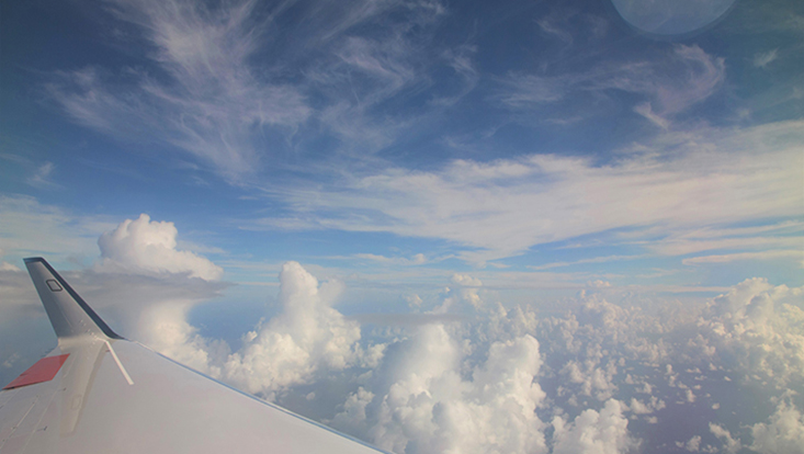
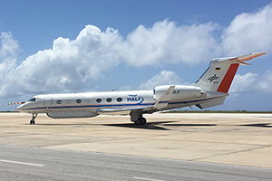
Heike Konow explores one of the last great mysteries of our climate system: the clouds. To do so, in several campaigns over a period of three years she and her colleagues investigated the sky over the North Atlantic – on board the research aircraft HALO, which took off from Iceland and Barbados. And so an enormous treasure trove of data was created, and this has now been made available around the globe.
Ms. Konow, the last IPCC Assessment Report referred to the influence of the clouds as one of the great unknowns in the climate system. What secrets are the clouds keeping?
How they organize themselves, how they are created, at what point they produce rain ... In order to understand the complete climate system, we need to know more about the causes and boundary conditions of all these processes. Only then will we be able to make model forecasts as accurate as we need them to be.
How does climate change affect the clouds?
We want to find out whether global warming will lead to more clouds. If so, it could rain more often. Theoretically this is the case, since a warmer atmosphere can hold more water. Whether these additional clouds then cause the climate to become warmer or cooler depends on how high up they are and what they are like. In short, high clouds have a shading effect, while low, dense cloud cover tends to warm the atmosphere.
With HALO, you have a unique research aircraft at your disposal. You have made the results from 37 flights from a total of four flight campaigns available to scientists around the globe. What makes this data so special?
We’ve created an enormous and unique database that can tell us a lot about the clouds. No one has ever before taken such systematic measurements over the North Atlantic. On land there are ground stations that regularly gather data – but above the sea? Although satellites continually scan the area measuring important parameters, at roughly 15km, the resolution is much too coarse to capture the clouds. In flight we can obtain measurements circa every 200 meters.

What do you measure?
HALO has a microwave radiometer and a cloud radar attached to its fuselage. These use electromagnetic waves, which I use to measure the clouds’ contours and also determine what they are like on the inside. If only a small portion of the waves are reflected, it means the particles and droplets in the cloud are small. If a lot of the waves are reflected, the cloud is, so to say, fully loaded and could possibly soon produce rain. At larger intervals we also release a so-called dropsonde, which floats downwards over a period of roughly ten minutes, continuously measuring the temperature, humidity, pressure and the wind. This gives us vertical profile of the atmosphere that we’re currently flying over.
Why don’t you simply put the data on the Internet after every flight?
It wouldn’t really be possible to work with it. I check the quality of the data at several levels. For individual minimum and maximum peaks, I check for potential sources of error. In addition I check whether all the equipment is time synchronized. For every full second of the flight, a dataset with the measurements from all the instruments is now available.
How do you know that the instruments measure correctly?
That was, in fact, a question at the beginning, since our instruments weren’t designed for flight. Would they tolerate takeoff and landing, and withstand being severely shaken about? They have to endure the large temperature differences between the sweltering Barbados airfield and the subzero conditions at altitudes of up to ten kilometers. We therefore tested them thoroughly on the first flights. We also made “parallel flights,” where we simultaneously flew the same route as a satellite with similar equipment. We were delighted when we compared the data: The instruments were robust enough for our high-altitude flights.

What happens on a flight?
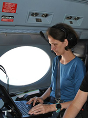
We fly for up to eight hours, from one side of the Atlantic to the other. On the aircraft it’s loud and we often wear earmuffs and headsets so that we can talk to each other. There are eight of us on board, five of whom conduct the scientific experiments. Some of the equipment is switched on before takeoff and some once we’re airborne. We monitor the instruments and the incoming data and try to rectify any problems. Since most of our equipment is mounted on the outside of the fuselage, we have enough space to move around.
Have you gained any new insights?
There’s a theory that the large-scale upward and downward atmospheric movements play a role. When air masses move downward, they force the clouds down. These remain small and finally dissipate. With updrafts, on the other hand, the clouds rise higher and can get bigger. Meteorologists have been working with this theory for a long time, and our measurements have now confirmed the link. It’s a great feeling to actually be able to measure something like that live in action.
What do we still need to know to better understand the climate system?
I’m particularly interested in at what point a cloud releases rain, and what the determining factors are. Does it depend on its size and surroundings? I am focussing on the typical shallow clouds, which strongly influence the climate in the tropical Atlantic, because they are so common. We already know that broad, shallow clouds rarely produce rain, while clouds that are deeper than they are wide are more likely to do so. That’s why, in late January, I’ll be going back to Barbados for the EUREC4A campaign. There I’ll gather more data and couple it with the current data.
More information
Dr. Heike Konow is a meteorologist, an expert on atmospheric measurements and a member of the CEN.
Publication: Konow, H., Jacob, M., Ament, F., Crewell, S., Ewald, F., Hagen, M., Hirsch, L., Jansen, F., Mech, M., and Stevens, B.: A unified data set of airborne cloud remote sensing using the HALO Microwave Package (HAMP), Earth Syst. Sci. Data, 11, 921-934, https://doi.org/10.5194/essd-11-921-2019, 2019.
The research aircraft HALO (High Altitude and Long Range Research Aircraft) can fly at particularly high altitudes of up to 15 kilometers and has a range of 8000 kilometers. It is capable of carrying up to three tones, so various measuring devices can be used simultaneously, either on board or mounted on the fuselage. Find out more
The Max Planck Institute for Meteorology, the Institute of Geophysics und Meteorology at the University of Cologne and Institute of Atmospheric Physics at the German Aerospace Center participated in the study.
Heike Konow has reported on her research in the newspaper Hamburger Abendblatt (in German): Was die rätselhaften Wolkenberge mit dem Klima zu tun haben

