WOCE Atlas


Topics
- Access
- Description
- Parameters
- Coverage, spatial and temporal resolution
- Data quality
- Contact person
- References
- Data citation and License
Access
UNRESTRICTED:
- View Atlantic Atlas data as picture: Levels | Neutral Surfaces
Description
The World Ocean Circulation Experiment (WOCE) was a part of the World Climate Research Programme (WCRP). Nearly 30 countries contributed resources to make unprecedented in-situ and satellite observations of the global ocean between 1990 and 1998. The WOCE Hydrographic Program (WHP) encompassed a range of physical and chemical measurements collected from research vessels mainly by means of Conductivity/Temperature/Depth (CTD) profilers and rosette water samplers. The WHP One-Time Survey provided high-quality basin-crossing ocean sections, along which temperature, salinity, dissolved oxygen, nutrients, CO2, CFCs and other parameters were measured.
Upon a completion of the WOCE Hydrographic Programm several projects have been started to produce hydrographic atlases for the Southern, Pacific, Atlantic, and Indian oceans based on the data from the WOCE Hydrographic Programme. Up to now only the WOCE Southern Ocean (Orsi and Whitworth, 1998) and the WOCE Pacific Ocean atlas (Tally, 2007) have been published and are available in a printed form.
Similar to the other WOCE atlases, the WOCE Atlantic Hydrographic Atlas consists of two parts:
- Sections: Parameter distributions along the WOCE hydrographic sections.
- Maps: Parameter distributions at standard depths and isopycnal (neutral) surfaces.
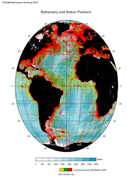
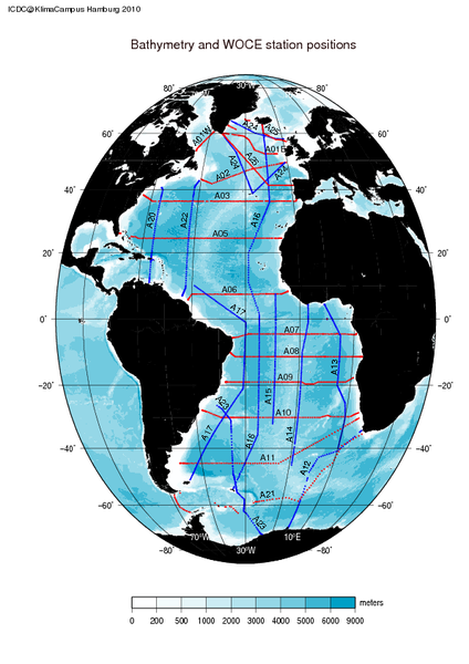
During the WOCE phase, observations in the Atlantic ocean on 13 (quasi) zonal and 10 (quasi) meridional hydrographic sections were made. Generally for each section there are distributions of temperature, salinity, density, neutral density, oxigen, nitrate+nitrite, silicate, phosphate and CFC-11, which are based on measurements. The atlas maps present distributions of the above mentioned parameters (except CFC-11) on depth levels (200,500,1000,1500,2000,3500 m and sea bottom) and on surfaces of neutral density (26.20, 27.22, 27.95, 28.05, 28.10 kg/m3). The data basis for these maps consists both of the WOCE data and selected quality controled data since 1970. These observational data were spatially interpolated and constitute the WOCE Global Hydrographic Climatology at ICDC. This gridded data set, which forms the basis for all maps in the atlas, has a spatial resolution of 0.5 degrees.
Last update of data set at ICDC: 2010
Parameters
| Name | Unit |
|---|---|
| Salinity | psu |
| Temperature | °C |
| Oxygen content | ml / l |
| Silicate content | µmol / kg |
| Neutral Density | kg / m3 |
| Nitrate | µmol / kg |
| Phosphate | µmol / kg |
Coverage, spatial and temporal resolution
Period and temporal resolution:
- 1970 to 1998
- no temporal resolution
Coverage and spatial resolution:
- Global oceans
- depth levels (200,500,1000,1500,2000,3500 m and sea bottom)
- surfaces of neutral density (26.20, 27.22, 27.95, 28.05, 28.10 kg/m3)
Format:
- Pictures (png, ps)
Data quality
No additional quality information available.
Contact
Stefan Kern
University of Hamburg
E-Mail: stefan.kern (at) uni-hamburg.deRemon Sadikni
ICDC / CEN / University of Hamburg
E-Mail: remon.sadikni (at) uni-hamburg.de
References
Literature:
- Technical Report: WOCE Global Hydrographic Climatology, ftp://ftp-icdc.cen.uni-hamburg.de/WOCE/climatology/observed_data/BSH35_report_final.pdf, (pdf, not barrier free)
Websites:
- Electronic Version of the WOCE atlas: EWOCE
- ODV WOCE Global Hydrographic Climatology, AWI, https://odv.awi.de/data/ocean/woce-global-hydrographic-climatology/
- WOCE Atlas Volume 3: Atlantic Ocean, https://sam.ucsd.edu/whp_atlas/atlantic_index.html
- eScholarship Permalink (pdf of print atlas): http://escholarship.org/uc/item/66z7j1xd
Data citation, License, and Acknowledgments
Please cite the data as follows:
Koltermann, K.P., V.V. Gouretski and K. Jancke. Hydrographic Atlas of the World Ocean Circulation Experiment (WOCE). Volume 3: Atlantic Ocean (eds. M. Sparrow, P. Chapman and J. Gould). International WOCE Project Office, Southampton, UK, ISBN 090417557X. 2011.
and with the following acknowledgments:
Thanks to ICDC, CEN, University of Hamburg for data support.
License
The data was published under the Creative Commons Attribution 4.0 International License (CC-BY-4.0).
